09/14/2011 to 09/20/2011
As usual, we never go just one place. After leaving Minnesota and all the fun there we headed home, but by a circuitous route. First we went through North Dakota, then Montana, followed by stops in Idaho, and finally revisiting Zion National Park.
Along the way we discovered some unusual finds, got a few things off our list of "must see" and added some more. Lists, lots of lists.
- Fort Abraham Lincoln State Park
- Theodore Roosevelt National Park
- Pompeys Pillar National Monument
- Nevada City, MT - Old Mining Town
- Arco - Atomic City
- Craters of the Moon National Monument
- Shoshone Falls - Idaho
- Zion National Park - Yes Again
- Angels Landing - Zion
Ft. Abe Lincoln was home to the 7th Calvary and the last posting for General Custer. It was from here that he set out on his last campaign, the debacle of Little Big Horn.
The Fort was established to support the building of the Northern Pacific Railroad. When that was completed the fort was abandoned. Portions of the it have been restored and period actors are on hand for tours.
The site also hosts a recreated Mandan Indian village named On-A-Slant because of the sloping location. The village was built in 1575 but abandoned in 1781 when smallpox ravaged the inhabitants.


The Barracks

The bunks in the barracks

One shallow fireplace to heat the barracks

The dinning hall. It probably was not this pretty in the old days

The Custer House. You can tour it with a guide but just our luck it was school field trip day.

The Custer House was very well appointed. Lots of fireplaces

The reconstructed Slant Indian Village

Rounded but very large inside


Inside one of the lodges were reconstructed fishing baskets and tools of the Mandan

The ceilings were very high

Supposedly the original lodge poles were equally as substantial

George is standing next to one pole to give a sense of scale

Ft. Abe Lincoln was also home to infantry, and they have reconstructed 3 blockhouses

Up the steep stairs to the top of the blockhouse

The entrance to the ramparts on top of the blockhouse

You get quite a view from up her. It was chilly and very windy when we were there. I can't imaging standing watch in winter
Located on the border with Montana, this park was created in the area first visited by Teddy Roosevelt and includes his ranch and original cabin.
There is an abundance of beautiful areas and supposedly lots of wildlife of which we saw little. Oh, well. That happens.
The park is located in the town of Medora. This is a really neat place that reminded us of a ski town. We would certainly stop there again if we are in the area.


Sweeping prairie shot. They had a lot of rain this year so everything is very green

The Little Missouri Badlands have some great formations

George is gesturing about something in that hill of sandstone

Pillars or maybe future short hoodoos

Yes, tons of prairie dogs. We restrained ourselves and only took several dozen shots


Heads popping up everywhere

We came across a band of wild horses. These are not mustangs but probably descendants of ranch horses

They were really beautiful

We loved this mare and her foal


The Little Missouri River

Our one and only buffalo
As we were driving west on I-94 through Montana we noticed a place on the map called Pompeys Pillar National Monument.
We had never heard of this, so we decided we would stop and see what it was.
By the name we expected something schlocky with only local significance. Boy, were we surprised.
This sandstone formation bears the only physical evidence of the Lewis and Clark Expedition. William Clark carved his name in the butte in 1806 on their return journey. He named it Pompey after Sacagaweas son whom he called "Pomp". OK, I have no idea why Pomp. However, it was a great find and we thoroughly enjoyed our stop.


The Visitors Center is quite unique for something built so recently.

Inside is a post and beam construction in keeping with the time of the Lewis and Clark Expedition era

There is an interpretive path that leads to the Pillar

Pompeys Pillar. Clark named it Pompeys Tower but that was changed by Mr. Biddle who first edited the expedition journals

UP - there is always an up

There are several dedication plaques as well as the preserved Clark signiture

Captain Clark

You get a great view of the Yellowstone River from atop the boardwalk
We love old ghost towns. These two do not quite qualify, but they were still interesting. Both contain historic buildings from the era, if not original to the towns themselves.
Nevada City tours and shops close at the end of summer, but we walked around a bit and saw what we could.
Virginia City has about 100 full time residence who keep the restaurant and some buildings open. I liken it more to Tombstone than a real ghost town.
We ate at the local saloon, but did not walk around mainly because it got very cold and rainy.

A little info on Nevada City

Some buildings along the street


The buildings cover all shapes and sizes


This was a great looking old home


Note the very tall outhouse

It is a double decker, complete with walkway. Classy

Yes, that is grass on top of the house


The Nevada City Hotel


Oh, ya. I broke out into song. Thanks Levon

This place is a mess, but the building has such interesting features
Arco has a couple claims to fame.
First, it is near what is now the Idaho National Laboratory. More then 50 nuclear reactors have been built here, and it has been the site of major testing for nuclear power.
Arco became the first fully nuclear powered town (for about a minute).
It was also where the Navy tested the big guns used on battleships before sending them off to be fitted on ships.
Arco also sits at the gateway to Craters of the Moon National Monument.

A tradition in Arco is for each graduating class to add their year to this butte

I love that they are so proud of this that they have a sign to explain it


This is the conning tower to the decommissioned nuclear sub USS Hawkbill. Why a sub tower on a plain you might ask


OK, the reason is this is the place holder for a future Idaho Science Center that will stress the role made by the Idaho National Laboratory to the understanding of nuclear power and of the thousands of US Navy Sailors who train
Another windy, chilly day but we just could not pass up seeing this park. Well, George saw it about 30 years ago, but for me it was the first time.
The lava formations are just wonderful and go on for as far as you can see. Caves, cinder cones, sparse vegetation in strange shapes - it is a great place


First stop, North Crater Flow Trail


Two great formations on the trail

They are trying to prevent any spread of white nose syndrome

Indian Tunnel

It was really hard to get any good shots of this tube because of the drastic changes in light and dark

Lots of pigeons in this cave just walking around

Strolling to the next path, and getting sand blasted - or should I say lava blasted

Inferno Cone was really neat. It is a bit of a hike up, but nothing hard.

The view from atop Inferno Cone

That is us getting blown around on top of Inferno

More views from the top of Inferno

Just some neat flow in the valley

I do not know if this is called Snow Cone Crater or Big Crater, but there are different areas formed by different events

Spatter Cones

Our artsy Rock and Moon shot. The moon was very prominent that day
Since we spent the night in Twin Falls , Idaho, we thought we might as well go see Shoshone Falls on the Snake River.
Although we had no real idea of what to expect we were happily surprised on how nice this park area is.
These falls are actually 45 feet higher than Niagara Falls. The park has walking paths and overlooks.
Also, this is where Evel Knievel attempted his rocket-powered cycle jump across the canyon. See, there is culture everywhere.


This just gives you a feel for the depth of the canyon

This is the community around the dam

Looking up the Snake River

The water moves at a very loud pace


A shot of one of the overlook stands


Rainbows from all the spray

Lots of spray

We liked that pinnacle rock - one of those things that just catches your eye.

That is the power station


I am on one of the overlook bridges - getting sprayed nicely


We also found these great, bright white shrooms

And these rather interesting ones as well
On our last visit to Zion it rained a lot. Oh lucky us. It hardly ever rains in Zion - or so the park rangers kept tellin us.
Add to that some of the sites we wanted to see were closed for repairs - well we just had to come back.
Our first stop was in Kolob Canyons and the Taylor Creek Trail. No surprise the geology is absolutely beautiful. It reminded us of some hikes in Sedona more than Zion


Shooting down the road from the trail head

Taylor Creek Trail

Lots of great scenery

Big red pinnacle rock

Yes, more great big red rocks

These valley shots were at the start of the trail

The first of many stream crossings


Jump from rock to rock

Larson Cabin is one of two historic homesteads along the trail

Cute little fixer-upper


Location, location, location

If you look down near the front door you can see the squirrel who seems to live under the cabin

We were trying not to startle him, until we figured out he just was not to be startled

He had a stash of nuts under the cabin

Another successful stream crossing with no slips - take a bow

You knew I would have more big red rocks

On the other side of the ridge the trail is all in shade

The colors of those big red rocks change in the shadows

Fife Cabin was the second old homestead


It also could use some repair


More trail along the stream


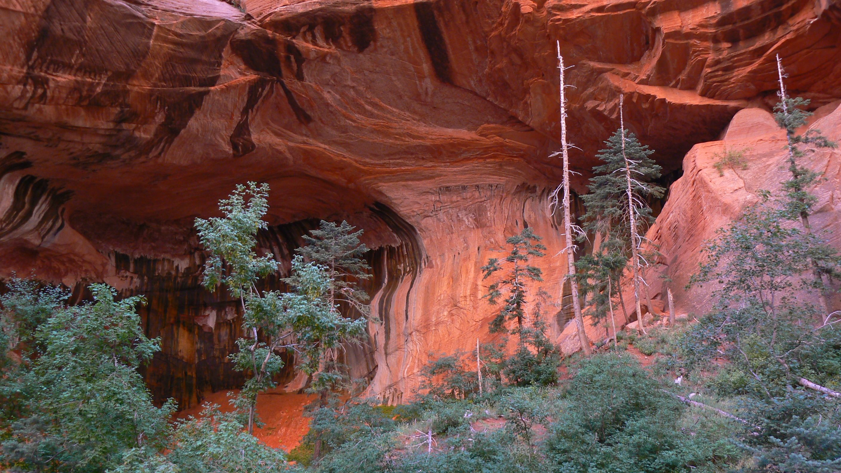
This is the reward for going all the way to the end of Taylor Creek

This double arch is just amazing. Naturally we took a bunch of pictures


On our last trip we could not do Angels Landing, partly because of weather and also because it was closed for maintenance.
So, this time the weather was great and there were no closures.
Nothing to stop us from making it to the top, other than blinding fear of falling to you death somewhere along the narrow, slippery route. Other than that, piece of cake.
After we descended we continued on the West Rim Trail for a few miles. From there you get a really good view of Angles Landing and if your camera has enough magnification, even the people on top.

The start to Angels Landing Trail

The usual great scenery of Zion

This is the easy part. You just need to be able to breath

You can see people scattered along the side of the mountain climbing up the trail

Looking back down the trail

It gives you some idea of the heights you have climbed when you look down the cliff face

More winding trail shots

That is Angels Landing. You traverse up the narrow ledge to the top. We took this from West Rim Trail after we had descended AL.

Notice the sign does not mention the deaths

That is Scout Lookout. Here is were you rest up for Angels Landing, continue on West Rim Trail, or head back down

Folks heading over to do Angels Landing

Starting up the trail

A bit farther up - you have to look close to see the people

I am coming back down, and yes, I used all the chains they had


This is where everyone is heading along that narrow path - Angels Landing. Look at the tiny people enjoying themselves

Just some pretty trees and rocks along West Rim Trail

Beautiful white sandstone

More contrasting colors and formations